Save Time and Achieve the Best Map Results with OfficeMap for MS Office!
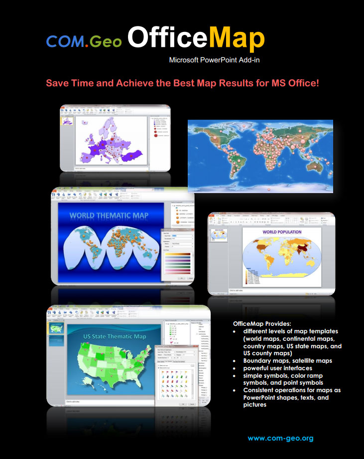 COM.Geo OfficeMap is the latest Microsoft PowerPoint Add-in. It provides a fast and easy way to directly create various kinds of maps on PowerPoint slides.
OfficeMap offers many map templates. The map templates for MS Office is an impressive collection of dozens of categorized maps with appropriate projections for PowerPoint slides. They include world maps, continental maps, country maps, US state maps, and US county maps. All boundary maps and some satilliate maps are provided.
OfficeMap offers three different symbol collections for simple symbols, color ramp symbols, and point symbols (i.e., markers, icons, and fonts).
The maps created by OfficeMap are composed of PowerPoint shapes, texts, and pictures. All of operations for texts and illustrations in PowerPoint can be directly employed to those maps within PowerPoint.
OfficeMap provides a friendly and powerful graphics user interface for users to easily insert the maps, select the symbols for the maps, and set the features for map shapes, texts, and pictures.
Energy Efficient GPS Sensing with Cloud Offloading
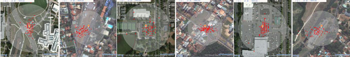 The goal of project CLEO is to develop device and services to encourage and enable participatory sensing and citizen scientists. A core technology developed in the project is to make location sensing energy efficient, so devices can be small, light, sample more frequently, and low cost. The approach is called Cloud-Offloaded GPS (or CO-GPS). A second service is a web-based sensor data management service called CLEO DB. It leverage SQL Azure and OData interface to support open data access.
Location is a fundamental service for mobile computing. Typical GPS receivers, although widely available, consume too much energy to be useful for many applications. Observing that in many sensing scenarios, the location information can be post-processed when the data is uploaded to a server, we design a Cloud-Offloaded GPS (CO-GPS) solution that allows a sensing device to aggressively duty-cycle its GPS receiver and log just enough raw GPS signal for postprocessing. Leveraging publicly available information such as GNSS satellite ephemeris and an Earth elevation database, a cloud service can derive good quality GPS locations from a few milliseconds of raw data. Using our design of a portable sensing device platform called CLEO, we evaluate the accuracy and efficiency of the solution. Compared to more than 30 seconds of heavy signal processing on standalone GPS receivers, we can achieve three orders of magnitude lower energy consumption per location tagging. Read more >>
Collaborate.org- Connect. Share. Change the World.
In the future, we need to work together to address the challenges we will all face- across individuals, NGOs, academia, and governments. We will need a collaboration and geospatial data infrastructure to empower that synergy, leverage our shared resources, and coordinate our actions. Collaborate.org is an open global online community of people, working together and sharing resources, expertise and enthusiasm, empowered with advanced collaboration and geospatial visualization technologies, to empower people to do Great Things.
Visual Explorations of Urban Mobility
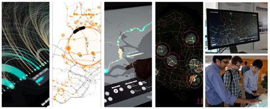 |
As digital technologies are increasingly deployed in transport networks, data generated by their operations can offer new perspectives onto a city's overall dynamics. When people move through the city, sensors and digital networks are at play, supporting their movements: electronic road pricing gantries, car-counting loop detectors, and public transport smart cards, to name a few, generate data as part of their operations.
In collaboration with Singapore's Land Transport Authority, MIT's Senseable City Lab has developed three interactive applications that provide insight into the wealth of information that the data generated by Singapore's transportation infrastructure offer.
Through these applications, experts and citizens alike can gain a better understanding on how people move through urban space, and explore the various narratives found within urban mobility. The interactive combination, and exploration, of these different data can also inspire new services and tools supporting current, and future, urban mobility options.
As part of the LIVE Singapore! initiative, these three
applications further explore how we can meaningfully enable the
combination of real-time urban data to enhance the design of new
solutions that address the opportunities and challenges of our
future cities.
Touching Bus Rides
Singapore's public transport system requires passengers to tap
their smart card passes when boarding and alighting subways and
buses. While these actions translate into different,
distance-based, fare prices for travelers, they also offer
perspective on the passengers aboard those vehicles at any given
time.
This interactive application puts that knowledge literally at
your fingertips. A multi-touch interface enables users to
actively explore Singapore's bus network, and see where most
passengers get on and off buses, how people connect between the
island’s stations, and the way these patterns changes throughout
the day.
Visualizing data on a large-scale multi-touch surface allows for
the application of novel interaction techniques to engage a
broad audience. The fluidity of the visualizations, with smooth
transitions and highly responsive interactions, creates an
enjoyable user experience to keep users engaged, and to
stimulate an informed debate.
Data Lenses
Data provided by the Land Transport Authority enable the accurate monitoring of bus activity at bus stops in Singapore. Due to the large volume of data, exploring the information at individual bus stops while also maintaining their geographic context is a challenge visually.
The data lenses proposed here are an interactive visualization tool that address this challenge. The lens acts like a magnifying glass, allowing the user to uncover layers of information that reveal at greater detail the activity of Singapore's bus network.
Traffic Origins
We all know that road accidents sometimes result in congestion, but how exactly does this happen?
By combining road-speed and traffic-flow data derived from LTA’s network of detectors with information regarding the location and time of traffic incidents, one can explore the dynamics of this phenomenon.
This visualization can furthermore be combined with simulation models to better understanding and predict how such disruptions may affect network performance, and how cities can better respond to traffic incidents and design a more robust road network. Read more >>